SERVICES
Within the themes of agriculture, land, and water management, MetaMeta provides expertise in various program stages, including: Program Management, Baseline & Feasibility studies, Monitoring & Evaluation, Research, Documentation, Capacity Strengthening, and Communication. Every setting, program, and partnership is different, and we adapt our approaches accordingly.
To ensure sustainability, we closely collaborate and co-design with communities and other stakeholders, whether that be at the program design stage, setting up an M&E system, or documenting stories of change. For effective upscaling, sharing of lessons learnt, and reaching everyone including marginalized groups, we work with and create participatory communication tools, interactive knowledge platforms, and horizontal, vertical and diagonal knowledge exchange.
We prefer to work with open access tools whenever possible and design on-the-job trainings to ensure effectiveness and sustainability of strengthened skills. Feel free to reach out through our contact page or email if you require more information.
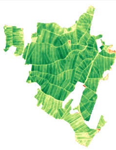
MetaMeta Kenya uses several tools and technologies for M& E i.e. Remote Sensing
Remote Sensing refers to the acquisition of data about an object without getting in physical contact with the object under surveillance i.e from airborne and space borne platforms. MetaMeta has adopted the use of both opensource satellite imagery datasets and high-resolution satellite imagery captured by drones.
With the fusion of our high-resolution drone images, open-source satellite images and on ground attribute datasets, we provide a range of services in line with our themes; we map, monitor and assess land degradation, invasive species mapping, Biomass estimation (through tree counting and tree volume calculations), critical area detection, crop health assessment, soil health assessment, soil moisture assessments, monitor trends in tree cover change, water resources, bare ground frequency changes, and land use land cover changes. This is provided at both large and small scale with an aim to promote natural resources management, agricultural and water productivity and a peoples’ livelihoods by influencing the decision-making process.